Gales Creek to Trask River Campground
through the woods to Nestucca River Road
Adding in a paved loop, it's 150
miles of fun, with about 14 miles of gravel through the forest.
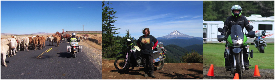
A motorcycle day trip in the greater PDX metro area.
 Follow
me! @coyotebroad
Follow
me! @coyotebroad
My tweets here are about travel, motorcycling, tent camping, bicycling
(mostly as a commuter), and things I find amusing. I tweet maybe up to
half a dozen times a day, on a really good day - usually much less.
Here is
the
Google
Map of the route. Sharing this mainly to help you navigate the
gravel from Trask River to Nestucca.
Get on Highway 6 going west from 26, if you are coming from Portland -
though we like to start from Gales Creek. Soon after you come out of
Tillamook Forest and the mountains and drop into the valley from the
mountains, you will take a left (and there is a left turning lane) on
Olsen Road - it's marked with a sign on the right just as you come into
the valley for Trask River County Campground. Take Olsen road and after
about a mile, make a left onto Trask River Road (there will be a sign for
it on the right).
Trask River Road is delightful. It's very curvy, a bit narrow and goes
along the river. Unfortunately there are very few places to stop and look
at what is truly the best part of the river, that gorgeous blue-green
water rushing over big boulders and various falls. If you see a safe
shoulder to stop that will give you a place to look at the water, take it.
Eventually you will come to Trask River County Campground. You cannot
miss it - it's on BOTH sides of the road. It's a great place to stop for a
pee break (at the vault toilets on either side). They also have water
spigots. If you decide to stop for lunch, you will be expected to pay the
$5 day use fee (which is great for one car full of people, but motorcycles
are expected to pay PER MOTORCYCLE and that's cr*p). Walk over and have a
look at the river if you have the opportunity and won't disturb any
campers.
Continue on Trask River Road and as you pass a luxury camp ground on the
right, the pavement ends and you are starting the 14 mile gravel route
that will eventually get you to paved Nestucca Road over.
Before I describe the rest of the route, note that, unless the road has
been freshly graveled or there have been some serious washouts, the road
is relatively easy - I say this as someone who does NOT consider herself
great at off-road motorcycle riding. In May 2022, when we rode it for the
first time, much of the road was so pounded down that it was like asphalt
and I didn't have to stand up. The difficulties of the road:
- Some of the gravel rocks are HUGE and some of the gravel where cars
aren't driving over regularly can be quite deep. Watch your riding line.
- On the weekends, this can get very busy with dirt bikes, four-wheelers
and trucks hauling such, as well as vehicles going to and from primitive
camp sites along the route.
- There is one really STEEP right turn, going up into a steep hill - you
have to commit absolutely to a good speed to turning and get up it.
- Some serious pot holes.
As I loathe going downhill on gravel, I recommend doing the route from
Trask River to Nestucca, NOT the other way around.
There are at least four official, designated primitive campgrounds on
this route and a lot more unofficial ones.
There are NO road markings on the gravel. Zero. So you need to put the
route into a GPS or download this
Google
Map of the route.
You come down to Nestucca Road on Ginger Creek Road - again, none of
the gravel roads are marked with signs, I just know this because of Google
Maps. Nestucca River Road is now entirely paved. Once there, you can
go to the left to Carlton and back toward Portland, or right to Beaver and
to the coast. Or you can make the trip even longer and go left toward
Carlton, then make the right for Bald Mountain Road and make the eventua
left to Willamina (have lunch at the Wildwood Hotel) or make the right on
Bible Creek Road and loop back to Nestucca, and then decide if you are
going to the coast or back to Carlton. OR, when you come from Ginger Creek
Road, you can go right on Nestucca, then make a left on Bible Creek Road,
and do the whole thing I've just said in reverse.
Here's
more about either of these additional routes.
You could even push yourself even harder and go to Bible Creek Road and
then head up
Siuslaw National Forest Service
Road 14 up the back of Mount Hebo. THAT is not easy, but if I can do
it, you probably can too.
There are numerous national forests roads all throughout this area, but
they rarely have road signs. The official, designated campgrounds along
the Nestucca River are great places to base yourself overnight to
explore the area, but frankly, I wouldn't leave anything in these
campgrounds during the day unattended for long amounts of time. Also,
these camp sites are usually full on the weekends, so you can't count on
one being available. As this is mostly national forest, you can legally
camp rough along most any gravel road.

Adventure Motorcycle Luggage &
Accessories
www.coyotetrips.com
Aluminum Panniers and Top Cases,
Top Case Adapter Plates,
Tough Motorcycle Fuel Containers, & More
Designed or Curated by an experienced adventure motorcycle world
traveler
Based in Oregon
You won't find these exact products anywhere else;
these are available only from Coyotetrips
(my husband)
_______________________________________________
If you have read anything on
coyotebroad.com
and found it helpful, or want to criticize it, PLEASE
let me know.
Comments are welcomed, and motivate me to keep writing --
without comments, I start to think I'm talking to cyberair. I
would welcome your
support for my
work as well.
 Quick Links
Index of resources for women travelers
(how to get started, health & safety considerations,
packing suggestions, transportation options, etc.
Advice for camping
with your dogs in the USA
Saving
Money with Park Passes in the USA
Advice for women motorcycle
riders and travelers
transire
benefaciendo: "to travel along while doing good." advice
for those wanting to make their travel more than sight-seeing
and shopping.
Suggestions
for Women Aid Workers where the culture is more
conservative/restrictive regarding women than most other
countries.
Where I've
been
A list of all of the states in the USA and all of the
countries I have lived in or traveled in, the farthest North
I've been by land, the nearest I've been to the equater,
various other stats.
This includes all of the places I have traveled to and through
via motorcycle.
Some
of
my favorite photos from my travels. Very hard to
pick favorites.
Advice
for Hotels, Hostels & Campgrounds in Transitional &
Developing Countries: the Qualities of Great, Cheap
Accommodations


Disclaimer: Any activity incurs risk. The
author assumes no responsibility for the use of information
contained within this document.
This material is provided as is, with no expressed or
implied warranty.
Permission is granted to copy, present and/or distribute a
limited amount of material from my web site without
charge if the information is kept intact and is
credited to Jayne
Cravens
Please contact me for
permission to reprint, present or distribute these materials
(for instance, in a class or book or online event for which
you intend to charge).
The art work and material on this site was created
and is copyrighted 1996-2024
by Jayne Cravens, all rights reserved
(unless noted otherwise, or the art comes from a link to
another web site).
The personal opinions expressed on this page are solely
those of Ms. Cravens, unless otherwise noted.